History of Punalu’u
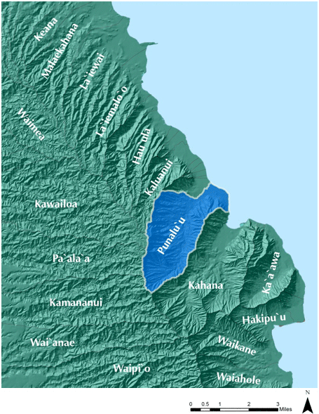
Punalu’u map (click to enlarge)
Punalu’u map (click to enlarge)
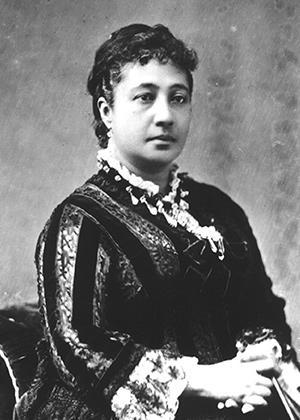
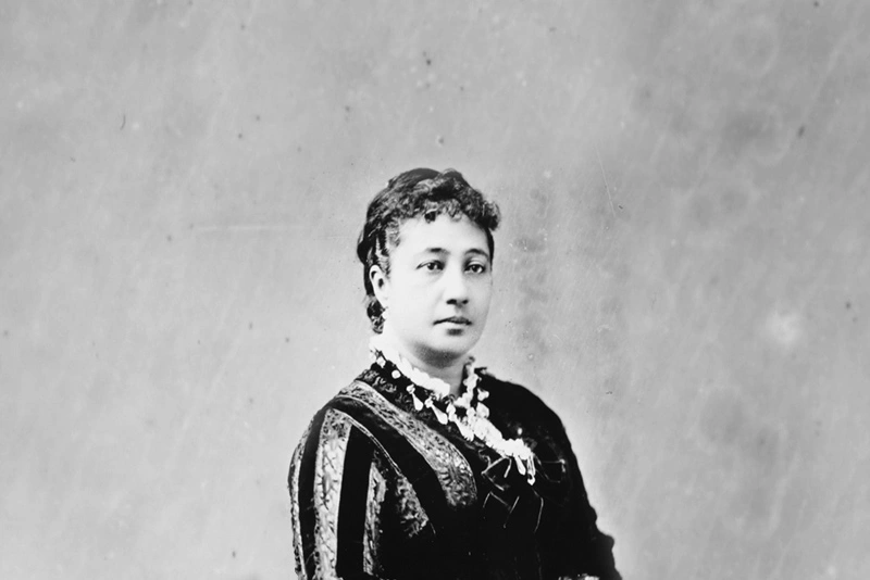
Bernice Pauahi Bishop
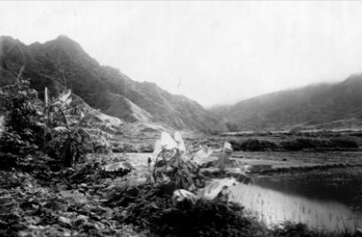
Archival photo of Punalu’u
Archival photo of Punalu’u
Location
The Ahupua’a of Punalu’u is located in the district of Ko’olau Loa between Kahana Valley and Hau’ula on O‘ahu. Kamehameha Highway runs along the makai portion of Punalu’u and is the only road that connects the area with the rest of the island. Punalu’u, like the rest of Ko’olau Loa, is predominantly rural. Small clusters of rural housing and a few country stores dot the agricultural landscape along either side of Kamehameha Highway. Punaluʻu Stream is recognized in the “Hawaii Stream Assessment” as one of the most biologically diverse and healthy streams on Oʻahu.
Environment
The area has a wet climate, receiving 60-80 inches of rain per year. As a testament to this wet climate, one of the Punalu‘u rains is referred to as Ka ua kīkē hala, or “the hala-pelting rain.” Located on the Windward side of O‘ahu, Punalu‘u receives gentle offshore trade winds from the northeast. From the famous legend of the Wind Gourd of La‘amaomao, moa‘e is a name of the wind within Punalu‘u, meaning “trade winds.”
Encompassing Lands
While Punalu’u is an independent ahupuaʻa, the name “Punaluʻu” is often used to reference a larger area that includes the ahupuaʻa of Punaluʻu as well as six smaller neighboring ahupuaʻa to the north: Waiʻono, Pūheʻemiki, Kapano, Haleʻaha, Papaʻakoko, and Kaluanui. Kamehameha Schools’ lands total about 3,600 acres, or approximately 60 percent of the larger area that is called Punaluʻu.
Meaning of Punaluʻu
Punaluʻu translates as “diving spring,” implying a spring of fresh water. The ahupuaʻa is well known for its abundance of water. The name “Punaluʻu” is also said to derive from the coral lime, known as puna, used for hair bleach. This correlates with the literal translation “coral dived for.” There is also another interpretation of “Punaluʻu” found in the Hawaiian language newspaper, Loea Kalai ʻĀina, which is a “spring in the sea of cool fresh water, cool as the water from the clouds when drunk.”
Natural Resources
The Koʻolau Loa District is traditionally noted in oral histories and written records as a place with an abundance of resources both in mauka and makai areas of each ahupuaʻa. The region is endowed with a plentiful water supply flowing from several major streams which include Kaluanui Stream, Punaluʻu Stream, Kahana Stream, Kaʻaʻawa Stream and Makaua Stream. Native plants in the upland forests included koa, olonā, hau, ʻōhiʻa lehua, and ʻōhiʻa ʻai.
Pre-Historical Land Use
In the 15th Century, Kalamakua, ruling chief of Oʻahu is credited with establishing numerous ʻauwai (irrigation ditches) and agricultural terraces throughout the island. These features were predominantly used for the cultivation of kalo (taro). In Koʻolau Loa, the development of these irrigation systems sustained a sizeable population for many generations. In Punaluʻu, the earliest accounts of the area note that an extensive loʻi kalo and ʻauwai system existed and that significant amounts of kalo were cultivated in the area. Kahana and Punaluʻu were known as the bread baskets of Koʻolau Loa.
Māhele ‘Āina
After the Great Māhele of 1848, the original land title of the Punaluʻu Ahupuaʻa was awarded to the great grandson of Kamanawa, William Pitt Leleiōhōkū, including 4,215 acres. Kamanawa was a trusted elder and advisor to Kamehameha the Great. Only 30 of 48 claims for kuleana in Punalu’u were awarded for a total of 89.25 acres. Eight claimants died prior to finalization of the awards, while 15 claims were disallowed. The original titles for kuleana in Punaluʻu Valley note usage for kalo, crops and house lots.
After his death, Leleiōhōkū’s lands were passed on to his son William Pitt Kīnaʻu. However, this son died young, and the lands were passed to his mother Luta “Ruth” Keʻelikōlani. Keʻelikōlani was a granddaughter of Kamehameha I. Upon Keʻelikōlani’s death in 1883, she passed her lands on to her cousin, Bernice Pauahi Bishop and her husband Charles Reed Bishop. Almost a year later in 1884, Bernice Pauahi Bishop passed away. Her combined land holdings, including those in Punaluʻu, were dedicated to the establishment of the Bishop Estate Trust and the Kamehameha Schools.
Historical Land Use
During the latter half of the 19th century, rice became the predominant cash crop grown in Punaluʻu. During the peak of rice production, “the ripening rice would turn the entire plain between the shoreline and the mountain side into a sea of gold undulating in the wind.” Initially, Chinese immigrants worked the rice paddies as laborers and, over time, some went on to become business and land owners in the area. The Chinese community in the area was estimated to have been between 300 and 400 people at one time. These Chinese immigrants and their descendants helped to shape the land and water development in Punalu’u and surrounding areas. Today, many of the old Hawaiian families in Punaluʻu and the surrounding areas are also descendants from the Chinese immigrants who settled in the region during the early days of rice cultivation.
The mouth of Waiʻono Stream served as an ideal harbor for coastal schooners and inter-island steamers because of its naturally carved deep channel. A pier was built out into Mamalu Bay and became a key trading point, bringing in outside supplies, while rice and other commercial crops were exported. The mouth of Waiʻono stream was also a good fishing ground for ʻoʻopu.
Around 1910, rice cultivation declined in Punaluʻu and the surrounding areas as older laborers could no longer tend to rice paddies and the local demand for rice declined. During this time as well, kuleana owners in Punaluʻu entered into lease-hold and sales agreements with the Chinese. As rice production declined, Chinese, and a growing population of Japanese farmers, began to revive and cultivate loʻi in Punaluʻu.
In 1906, seven Chinese immigrants involved in rice farming founded the Punaluʻu Yin Sit Sha or “debate society” to discuss the political disorder occurring in China at the time. As the organization evolved over time, the Punaluʻu Yin Sit Sha shifted its focus from mainland China issues to local issues. The organization served as a school and local civic center. Today, there is still a strong Chinese presence in Punaluʻu. The Punaluʻu Yin Sit Sha has property holdings in the area and holds several cultural events every year including memorial services, picnics and anniversaries.
Also in 1906, Bishop Estate entered into a new lease agreement for its lands in Punaluʻu with James B. Castle after the Estate’s prior lease agreement with a Chinese Hui expired. Castle created the Koʻolau Agricultural Company. In the first years of Castle’s management of the lands, hundreds of acres of land were leased to Japanese tenants for the cultivation of taro and pineapples. Castle also constructed the Punaluʻu Ditch system around this time. The ditch network consisted of a diversion dam, flume, 12 tunnels and a series of smaller ditches that spread across Punaluʻu, Makaua, and extended four miles to Hauʻula. Water was diverted from Punaluʻu Stream at about the 210-foot elevation.
The Punaluʻu Ditch system was originally constructed to irrigate sugarcane lands in Punaluʻu. In 1905, the Koʻolau Railway Company obtained an easement for its line through Punaluʻu. The rail line extended 11 miles along the Ko’olau Loa kula lands from Kahana to Kahuku and was completed in 1908. Concrete-lined irrigation channels were added to the ditch system in 1922 to transport water. Sugar was cultivated in Punaluʻu until the 1970s.
The Punaluʻu Ahupuaʻa Plan
Kamehameha Schools assumed day-to-day operations of its Punalu’u lands in 2000. In May of 2010, KS finalized the Punaluʻu Ahupuaʻa Plan, an organizing document that provides guidance and strategies for managing agricultural, commercial, residential and conservation lands in Punaluʻu Valley, and aligns future projects and programs with the organization’s broader Strategic Plan Goals. The Ahupuaʻa Plan was created after nearly a year of meetings which generated valuable input from residents, community leaders, educators and farmers. The following Vision Statement was written to capture the spirit of the Ahupua’a Plan:
He ʻĀina Momona O Punaluʻu (“Punaluʻu is a place of abundance”)
“Our relationship to the ʻāina and our Hawaiian values sustain the traditions and productivity of the ahupuaʻa, stimulate learning opportunities, nurture a healthy community and perpetuate its rural character.”